NBCS Educational Handbook – back by request….
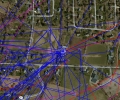
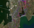
In 2005 NBCS was just starting to track and GPS collar coyotes. As we began to develop our ideas about coyote behaviors and resource use, we though it would be great to involve kids in the initial discovery phase. As background, we prepared The NBCS Educational Handbook which provided K-12 standards-based lessons about coyotes from which teachers could select based on their interests.
Also that year ESRI donated ArcGIS mapping software to 15 schools that were interested in the project (hence the section on GIS methods). We assembled teachers for a week of summer training on ArcGIS so they could teach and work with their students mapping our data and looking for patterns in coyote behavior as the GPS positions of each animal, and the packs they belonged to, accumulated.
We are now reposting the “Handbook” to help new schools and programs get their own curricula started. Schools won’t need GIS – we will periodically be posting interactive maps of RI coyote movements on our online server. This should connect students to real data in real time. Reminder: The NBCS handbook is password protected; please write us at coyote@theconservationagency.org to request it.
Related Articles